14 Days 13 night
Naadam Tour
Prices from 900€
Mongolia and Naadam – Full English Translation
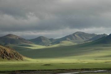
In the minds of many travelers, Mongolia evokes vast plains, the yurts of nomadic herders, untouched and desert-like expanses, and one of the most famous warriors of all time, Genghis Khan, whose legendary exploits continue to resonate throughout this magnificent country.
The history of Naadam goes back more than 2,000 years. At that time, it was a way to select and train warriors for upcoming battles, as the tribes living in the Central Asian steppes regularly attacked each other.
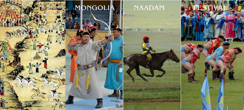
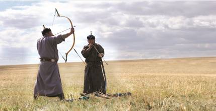
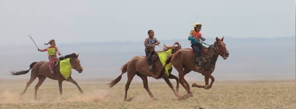
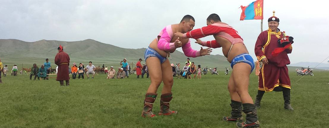
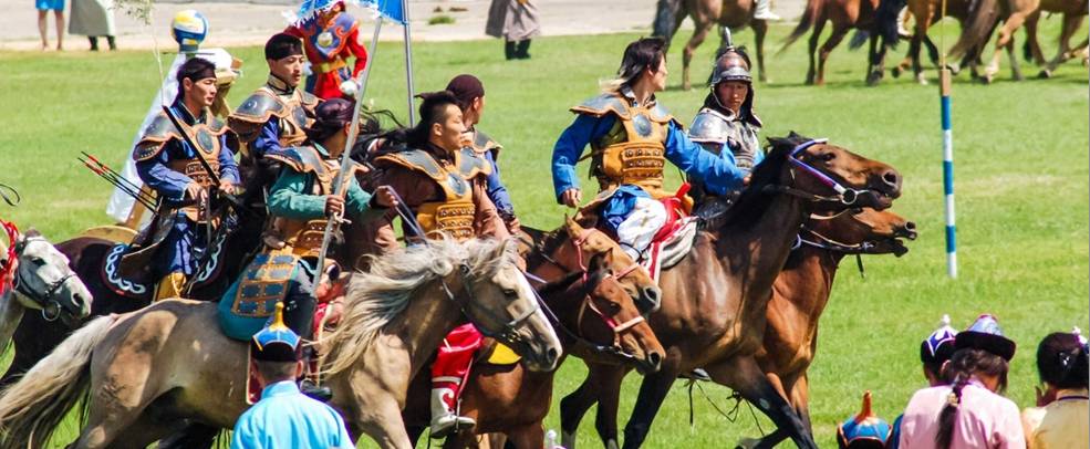
During that era, the great Mongol kings and generals trained their warriors while competing and celebrating. Their main disciplines were wrestling, archery, and horsemanship.
Today, Naadam still includes these three practices, directly linked to the art of war and now recognized as traditional sports, while also incorporating more modern games such as ankle bone shooting.
We offer you an itinerary at the heart of the central steppes, centered around Mongolia’s most cultural and traditional festival: Naadam!
A journey from July 5 to 18, 2025,
to attend one or several Naadam festivals in Arkhangai,
with our nomadic friends, far from the capital, for greater authenticity, spontaneity, and meaningful encounters.
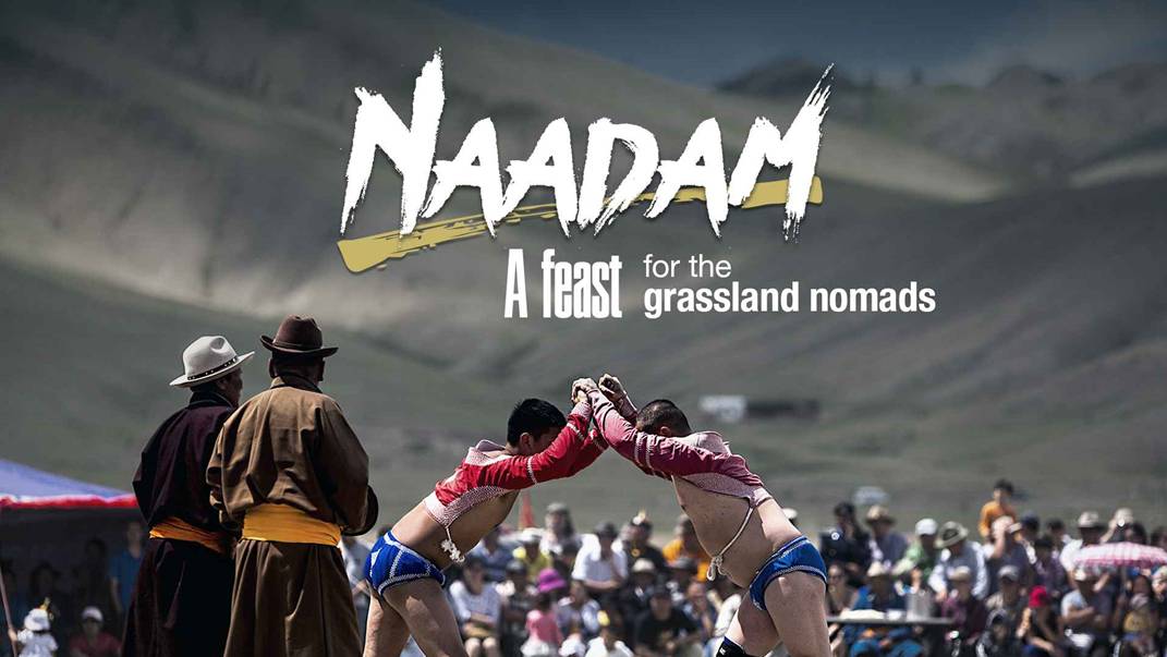
Naadam, also called “Eriin Gurvan Naadam”, translates as “The Three Manly Games.” Its history dates back to the great era of the Mongol Empire. According to some historical accounts, at the beginning of the 13th century, after Genghis Khan had defeated his enemies and ruled over the Mongol tribes, he organized games as a celebration. The word Naadam means “competition” in Mongolian and was associated with this first celebration, which included the three martial arts of Mongol warriors: mastery of horse racing, wrestling, and archery.
According to historical accounts, after Genghis Khan organized the first games as a celebration, a stele dating from the 1200s was erected in honor of a noble named Yesunge, who succeeded in hitting a target with an arrow from a distance of over 500 meters. This stele bears the first known Mongolian script.
Later, during the Qing dynasty, Naadam became an official celebration, organized in every village. Naadam in its current form has been celebrated as a national holiday since the Mongolian People’s Revolution of 1921.
Many other Naadams are also organized throughout the country during the summer season. In villages, these Naadams serve as qualifying events for provincial Naadams, which in turn qualify participants for the National Naadam held in the capital. However, many Naadams have always been held for various celebrations such as weddings or births, throughout the year.
Your Journey at a Glance
Day 1 – July 5, 2025 – Arrival in Ulaanbaatar – City tour
Overnight in a hotel in Ulaanbaatar
Visit Gandan Monastery and the Genghis Khan Museum
Meals are at your own expense
Day 2 – Ulaanbaatar – Kharkhorin
Overnight with a family, in a guest yurt, or at a yurt camp
Distance: approximately 420 km – Driving time: 4–5 hours
Kharkhorin: 47°11'55.0"N 102°50'14.6"E
Day 3 – Kharkhorin
Overnight with a family, in a guest yurt, or at a yurt camp
Visit Erdene Zuu Monastery, Kharkhorin Museum, and the Calligraphy Art Center – Erdenesiin Khuree
Day 4 – Ikh Tamir
Overnight with a family, in a guest yurt, or at a yurt camp
Archaeological discoveries
Distance: 280 km – Driving time: 4 hours
Ikh Tamir: 47°35'12.0"N 101°13'13.2"E
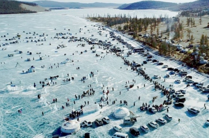
Day 5 – July 9 – Ikh Tamir Naadam
Today marks the start of the Naadam festival in this small village!
Overnight with a family, in a guest yurt, or at a yurt camp
Day 6 – July 10 – Tsetserleg & Naadam
As in many provincial capitals, the celebrations begin on July 10.
Overnight in a local hotel or yurt camp
Distance: 40 km – Driving time: 1 hour
Tsetserleg: 47°28'21.3"N 101°27'35.8"E
Day 7 – July 11 – Second day of Naadam in Tsetserleg
Overnight in a local hotel or yurt camp
Day 8 – Orkhon Valley
Overnight in a yurt camp
Distance: 250 km – Driving time: 4 hours
Orkhon Valley: 46°50'28.7"N 102°08'52.7"E
Day 9 – Orkhon Valley & hike to Tuvkhun Monastery
Overnight in a yurt camp
Distance: 50 km – Driving time: 1 hour
Tuvkhun Monastery: 47°00'46.0"N 102°15'19.4"E
Day 10 – July 14 – Orkhon Valley – Khadag Festival in Bat-Ulzii
Overnight in a yurt camp
Distance: 50 km – Driving time: 1 hour
Bat-Ulzii Village: 46°49'34.1"N 102°14'39.1"E
Day 11 – Khogno Khan Sand Dunes
Overnight in a yurt camp or with a nomadic family
Distance: 280 km – Driving time: 4 hours
Khogno Khan: 47°17'11.2"N 103°43'38.5"E
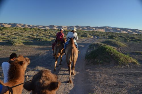
Day 12 – Khogno Khan – Camel ride across the dunes
Overnight in a yurt camp or with a nomadic family
Day 13 – Return to Ulaanbaatar
Distance: 350 km – Driving time: 4 hours
Day 14 – July 18 – International flight
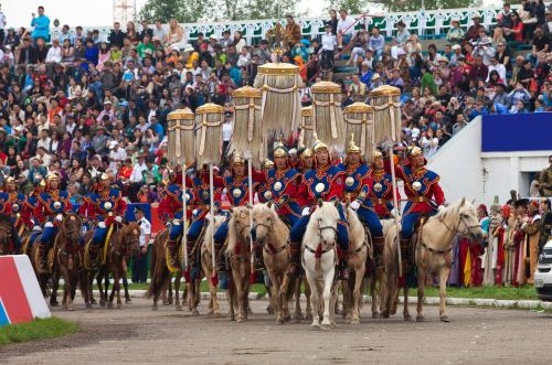
What is modern Naadam?
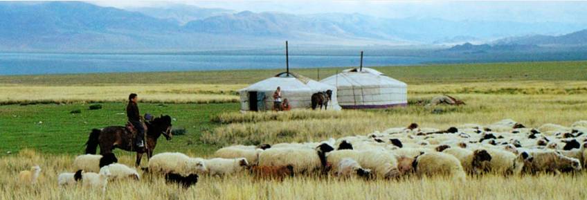
Today, Naadam is a festival that celebrates the national holiday every year from July 10 to 13 throughout Mongolia. The Mongolian Naadam is inseparable from Mongolia’s nomadic civilization, whose people have long practiced pastoralism across the vast Central Asian steppes.
Oral traditions, performing arts, national cuisine, handicrafts, and cultural forms such as long songs, Khöömei throat singing, Bie biyelgee dance, and the traditional Morin Khuur (horsehead fiddle) also play an important role during Naadam.
Today, it is an annual event, a national celebration of sports and arts attended by thousands of Mongols with great respect, continuing ancestral rituals such as wearing their finest traditional costume, the deel. Most games are open to participants of all ages and genders, except wrestling, which is reserved for male athletes.
Ritual songs of praise and poems are dedicated to participants of each event.
It is thus the largest event in Mongolia, where the provincial capitals of the 21 aimags celebrate their traditional nomadic culture and heritage simultaneously.
The 333 soums (small villages) celebrate their own Naadams, often on different dates, depending on special occasions or anniversaries, which can occur at various times of the year.
“The Mongolian Naadam is inseparable from Mongolia’s nomadic civilization,” can be read in the inscription on the UNESCO Intangible Cultural Heritage of Humanity list, dating from 2010.
In 2020, the Mongolian government extended the national Naadam holiday from three to five days, and much of the country is closed during this period.
Naadam is also one of the most popular times for travelers visiting Mongolia, with more than 15,000 foreigners coming specifically to attend the games in 2023.
From its distant history, when the great warlords selected their best warriors during competitions while celebrating, remains the tradition that both Mongols and travelers must eat khuushuurs, a type of fried dumpling filled with minced meat, cooked in mutton fat and vegetable oil, known as “Naadmin Khuushuur.”
Places Visited
Ulaanbaatar
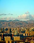
Ulaanbaatar, formerly called Urga, is built on the banks of the Tuul River, in honor of the son of a great Mongol lord.
The name Ulaan Baatar was given to the capital at the proclamation of the Mongolian People’s Republic, meaning “Red Hero.”
The streets of the capital are particularly busy in summer, and there is a constant hustle and bustle, even late at night.
The city is divided into several districts, showing great diversity, and one can still see a few yurts in the city center. The growth of Ulaanbaatar is surprising, and in the capital, one finds all the amenities of modern life.
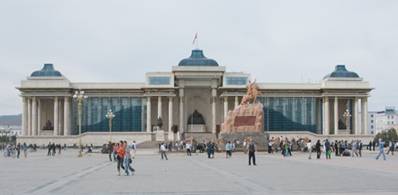
City tour of Ulaanbaatar
For the discovery of the capital, several visits are proposed:
-
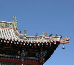
Gandantegchinlen Monastery in the morning to attend the ceremonies: It is the most important monastery for Mongols. Built in 1809 under the name Sharsum by the 5th Javzandamba, then the highest lama in the clergy hierarchy, it took its current name in 1838.
-
The main temple Megjid Janraiseg (Avalokiteshvara) was built between 1911 and 1912 to celebrate the end of Manchu rule and also as an offering to obtain the healing of blindness for the Bogd Gueguen. It is of Sino-Tibetan mixed style. Its unusual height allows it to house an immense statue of Avalokiteshvara, of invaluable worth and 25.6 meters high. Destroyed and removed in pieces by the former USSR at the end of the 1930s, it was rebuilt alongside temple restoration work in 1996.
-
Natural History Museum: Created in 1924 as the National Museum, it became the Central State Museum in 1956. Later, in 1997, it expanded to become the Museum of Natural History. The museum covers geography, flora, fauna, and paleontology. A total of 800 paleontological objects are exhibited, along with a chart depicting the evolution of life over 500 million years. The petrified forests (10–15 million years), plants, dinosaur fossils, and stuffed mammals are also on display.
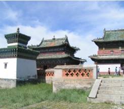
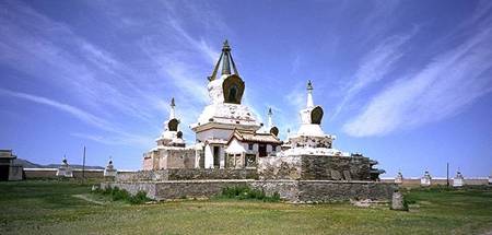
Kharkhorin
Karakorum enjoyed the splendor of an imperial city for about 140 years but was the capital of the empire for only 32 years. In 1235, Ögedei, son of Genghis Khan, built a protective wall over 2 km around the city. It was also at this time that the city became a center of economic and political activity.
However, keeping their nomadic customs, members of the royal court did not live in the palace, which served only for receptions, but around the capital in yurts.
From this rich imperial city, little remains, as bricks were used for the construction of Erdene Zuu Monastery on the exact site of the former city.
The city itself was used as a “meeting center” for various lords and only housed the grand Khan’s court. It was completely destroyed by the Ming dynasty in 1380.
Present-day Karakorum is located a few kilometers from there. The remains of this enormous city are visible in the surrounding hills. Currently, Karakorum is the administrative center of the region and a major agricultural hub, with an irrigation canal coming from the Orkhon River.
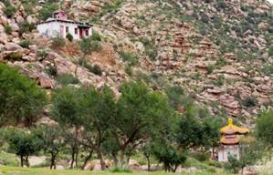
Erdene Zuu Monastery was built on the ruins of the ancient city. Despite the destruction of part of the complex, it remains one of the three most important and most visited monasteries in the country. Its founder, Altan Khan, initiated the development of Buddhism in Mongolia.
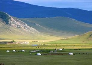
Ikh Tamir Valley
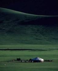
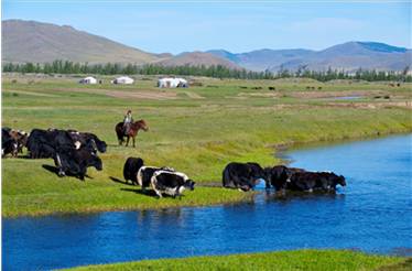
Ikh Tamir is a small village not far from Tsetserleg, the capital of Arkhangai province, located on the banks of the Tamir River, at the entrance of a superb green valley where many nomadic families live, with yurts scattered across pastures grazing yaks, cows, horses, and sheep.
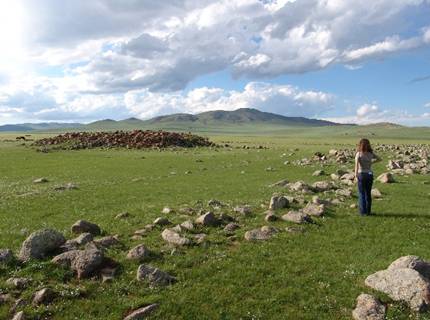
The Tamir Valley is also well known among archaeology enthusiasts for its rich sites, the most famous being Mongon Mod and Tsatsiin Ereg, which contain numerous burial mounds and standing stones, remnants of ancient nomadic civilizations.
A gem of archaeology is nestled on the hillside; tombs, deer stones, and rock paintings give Tsatsiin Ereg another dimension, linking past and present… one can almost hear the gallop of Khunuus warriors.
About 1,500 years before our era, unified tribes of nomadic horse riders practicing pastoralism lived in present-day Mongolia. Did these herders erect and carve these stones as offerings to the spirits of the steppes, or were they simply markers for burial grounds?
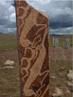
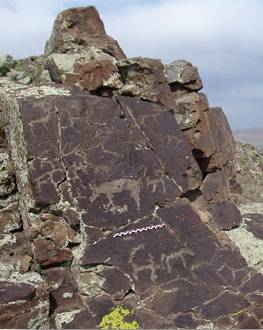
Or perhaps they were the Khunuus or Xiongnu warrior hordes, the “Wailing Barbarians” mentioned in ancient Chinese texts, a people of conquering horsemen whose martial spirit terrorized Central Asia. The Great Wall was constructed to protect China from regular Xiongnu raids.
Not to mention the richness of the petroglyphs decorating the basalt cliffs overlooking the valley. Mixed drawings, scenes of wolves hunting goats and deer, archery hunts, different styles, different eras – were these simply depictions of daily life or symbolic of cult practices?
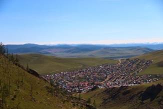
Tsetserleg
Tsetserleg is located between the Tamir and Chuulut rivers. This town is known for being the greenest city in the country. The name Tsetserleg, meaning “garden,” comes from the word Tsetseg, meaning “flower.” It is situated on the northeast slopes of the Khangai Mountains and covers an area of 540 km², about 500 km southwest of Ulaanbaatar.
The town was built on the site of one of the country’s most important monasteries, and numerous remnants of this past can be found throughout the city.
Tsetserleg has a very rich history, due to its pastures as well as the various hot springs in the region.
Visitors can also explore Zayan Gegeen Monastery at the foot of the mountain.
Tsetserleg is the capital of Arkhangai Aimag (province). Since 1992, it has been called Erdenebulgan to avoid confusion with another Tsetserleg located further north.
In 2006, its population was 16,300 inhabitants.
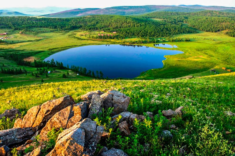
Orkhon Valley
The Orkhon Valley is the emblem of Mongolia, a magnificent natural site. It is a fertile valley renowned throughout the country, home to many nomadic families.
This valley is located in the northern part of Ovorkhangai, in the heart of the country, within the Khangai Mountains. It was inscribed as a UNESCO World Heritage site in 1992, with a protected area covering about 122,000 hectares of grassland.
It is also a region of great archaeological richness, as the Orkhon basin has hosted successive nomadic cultures since prehistoric times.
Throughout history, successive waves of nomadic peoples found the Orkhon Valley suitable for settlement. The earliest traces of human occupation date back 60,000 years. The valley has been continuously inhabited by the Huns, various Turkic peoples, the Uighurs, the Khitans, and finally the Mongols.
Today, numerous archaeological remains are scattered throughout the region, such as Turkish memorials from the 6th and 7th centuries, Khar Balgas, the Uighur capital during the 8th and 9th centuries, and of course Kharkhorin, the Mongol capital in the 13th and 14th centuries, founded by Genghis Khan.
Several monasteries can also be visited, such as the Tövkhön Hermitage and Shankh Monastery, which bear witness to the religious traditions of nomadic Mongols.
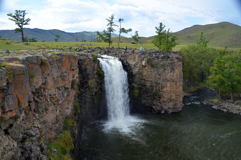
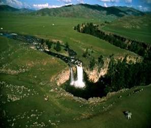
Orkhon Waterfalls
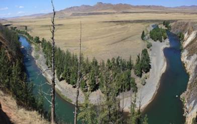
The Orkhon River is one of the most iconic images of Mongolia. At 1,120 km long, it is the longest river in Mongolia, flowing into the Selenge River, which empties into Lake Baikal.
About 20,000 years ago, following a violent volcanic eruption, a 26-meter-high fracture formed, into which the Ulan Tsutgalaan River joins the Orkhon River, giving birth to the famous waterfall.
The waterfall is, of course, part of the UNESCO-protected zone.
The Orkhon River is a wide river, ranging from 10 to 60 meters, eventually widening to over 100 meters before joining the Selenge.
Many fish species inhabit the Orkhon River, such as pike, Siberian sturgeon, taimen, Siberian grayling, roach, and others.

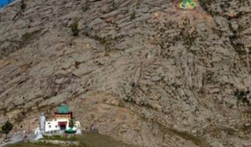
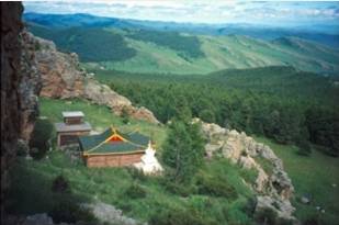
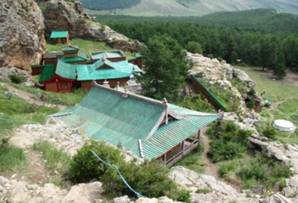
Tuvkhun Monastery
Tuvkhun Monastery, in Mongolian Tuvkhun Khiid, was built in 1654 by Zanabazar, one of the greatest representatives of Buddhism in Mongolia, who was also an artist and sculptor. It is located at 2,300 meters above sea level on a rocky hill surrounded by forests.
In 1648, the Shankh Monastery was being constructed nearby on the Shariin River. Zanabazar noticed a rocky peak shaped like a chair to the west of the Orkhon River, called Shireet Ulaan Uul. In 1651, after returning from his first trip to Tibet, he built a small stone structure on this rock spur for personal meditation. During Zanabazar’s life, this temple, where he often stayed, was called Bayasgalant Aglag Oron (“happy secluded place”).
After his death, the monastery was renamed Tuvkhun. The small temple was heavily damaged during Soviet purges and was renovated in the summer of 1997, with ceremonies held there and a new statue of the deity Gombo Makhagal installed. Several monks live full-time at the monastery.
Near a rocky spur lies the “Throne of Zanabazar”, a stone seat where, according to resident monks, Zanabazar sat each morning at dawn; nearby are visible several footprints, one said to be his barefoot and another wearing traditional Mongolian boots, as well as a footprint said to belong to his horse.
To the right of the temple, a path leads upward to the summit of the rock. One branch of the path passes through a narrow passage that pilgrims crawl through symbolically to be reborn; this passage is called “the Mother’s Womb.”

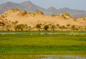
Bayan Gobi or Khogno Khan & Elsen Tasarkhai
Bayan Gobi, more commonly known as Khogno Khan, refers to the granite massif, while Elsen Tasarkhai refers to the sand dune cordon.
Bayan Gobi means “Rich Gobi” and is also called Little Gobi, consisting of a long dune line stretching 80 km at the heart of the granite massif.
Khogno Khan is a national park of primary importance, located just off the main Ulaanbaatar–Kharkhorin road, covering 46,900 hectares.
The rocky massif rising above the dunes creates a surreal atmosphere. It is a superb place for hiking, and with some luck, visitors can observe wildlife such as deer, ibex, and a wide variety of birds.
Nestled on the hillside is the Uvgun Khiid Monastery (khiid meaning monastery), an architectural monument from the time of the western Mongol invasion by Khan Galdan. Destroyed several times, most of this 17th-century Buddhist monastery remains in ruins.
The name Uvgun means “old man.” According to legend, the monastery was built in the mid-17th century by Tibetan monks during their exile in Mongolia. Lkhalambaldorj Lama constructed the monastery during his exile.
According to scholars, the monastery was inhabited for at least 50 years. During the Khalkha-Oird war, it was burned and lost all its splendor. In 1693, Zanabazar built another monastery called Erdene Khamba, commemorating the original monastery.
Much later, in 1937, numerous religious and artistic objects were transferred to the newly constructed monastery, but during the Soviet era, the monastery suffered further destruction.
It was only in 1992 that the monastery was rebuilt, consisting of a stupa and a main temple, with renovations completed recently, in 2004. Few monks live there, but the monastery remains active.

Logistics & Pricing 2026
Guiding & Logistics:
-
1 French-speaking guide
-
1 4x4 vehicle with driver
All-inclusive price:
-
Guiding, vehicle, fuel, accommodation, meals (except in Ulaanbaatar), visits, entrance to the national park, horse riding, camel riding, etc.
Dates: July 5–17, 2025
Group size: 2–6 persons
Activity: Around the Mongolian Naadam – Horse trekking, hiking & discovery of nomadic life
Transport: Japanese 4x4 vehicles
Accommodation: Choice-based – Guest house in UB and yurt camps or nomadic family stays along the route
Price per person:
| Group Size | Basic Option | Medium Comfort | Comfort Option |
|---|---|---|---|
| 2 persons | €2,820 | €3,350 | €3,760 |
| 3 persons | €2,230 | €2,720 | €3,060 |
| 4 persons | €1,870 | €2,340 | €2,620 |
| 5 persons | €1,770 | €2,230 | €2,500 |
| 6 persons | €1,610 | €2,050 | €2,240 |
Tours